It’s no secret that weather can be predicted. We all scan weather apps on our smartphones whenever we’re planning a camping or hiking trip. Sure, these weather forecasts don’t play out perfectly. (Surely we’ve all been caught in a freak hailstorm or heavy rain once in a while). But as technology has advanced, humans are increasingly able to predict weather patterns across the Earth’s surface.
The same has been true on water for years… but not for everyone.
54-year-old New Zealand Olympic sailor Jon Bilger experienced this firsthand, after helming an America’s Cup forecasting team for a decade. Found in 1851, the America’s Cup (or “Auld Mug”) yacht race is the oldest international competition in any sport, and among the most prestigious events in the sailing world. Following an Olympic appearance in 1992, Bilger served as a navigator for TAG Heuer in 1995, then won the race twice as weather manager for Alinghi, in both 2003 and 2007.
“It was a stressful job,” Bilger said. “We were responsible for telling the boat(s) which way to go for every three-mile beat, [but] even when you have a man up the rigging, you can only see a half-mile up the [30-mile] course.” As one can imagine, even at the turn of the century, the technology behind the meteorological program was extensive. Bilger was part of a 12-person team made up of weatherboat drivers, meteorologists, and other experts. “We had incredible technology, satellite equipment, weather stations, pressure sensors everywhere,” he said. “We had these motorized hang gliders flying around the course… We just had some really cool technology.”
With this extensive meteorological support, Bilger and his team were able to dial in weather conditions to an unprecedented level… certainly compared to what the average sailor might have access to.
But after spending over a decade working with this technology, Bilger realized that all this elite technology didn’t have to be relegated to elite yacht racing. He wanted to bring it to the masses. “I started thinking, ‘Imagine if the average sailor had access to this technology?’” he said. “I realized from working with top meteorologists that 90% of what they're saying is just the model. If you get the best model data and you present that properly, then you can [help sailors] make a really good call.”
With this drive in mind, Bilger designed PredictWind, a weather forecasting platform allowing sailors worldwide to get their hands on meteorological technology previously exclusively available only to high-end sailing races and expeditions.
PredictWind synthesizes (“What we and our team believe”) are the top six weather forecasting models available at any given moment, giving sailors access to tools and information like real-time weather updates, an advanced forecasting model, and intuitive route optimization features. Bilger said this revolutionizes the way everyday sailors can navigate open water.
It wasn’t all smooth sailing. When Bilger first tried to start PredictWind, back in 2008, “It was pretty sketchy,” he admitted. “I built it all the wrong way. These days, you go and get investors, you crowdfund or whatever. But I just put all my money into it, myself and my wife. And three or four years into it, it was like, ‘Don't worry darling, we won't lose the house. We'll be fine…’”
For several years, Bilger said he considered pulling the plug. In recent years, however, PredictWind really took off. He now employs 50-odd people, “and it's been growing every year. It's very successful. But [back then], it was crazy town. Just crazy town.”
Like planning a road trip—easily thrown into disarray by traffic jams and road closures— unpredictable weather patterns can occur on the water as well. Bilger mitigates this risk by offering real-time updates through PredictWind’s mobile app, along with fully interactive maps and push notifications, allowing sailors to stay informed and adapt their plans in a split second on the water.
Another key feature is PredictWind’s ability to provide customized route planning based on individual preferences and vessel specifications. Sailors can input their starting point, destination, and any specific requirements, and the platform generates optimized routes that consider wind patterns, currents, and potential hazards. This saves time and fuel and enhances safety by guiding sailors through the most favorable conditions.
Additionally, PredictWind offers comprehensive weather forecasts that cover a wide range of parameters, including wind speed, direction, wave height, atmospheric pressure, and more. The platform’s user-friendly interface lets sailors easily interpret and visualize the data, allowing them to make informed decisions about their routes and activities.
Thanks to GPS tracking and AIS (Automatic Identification System) maritime data, PredictWind lets sailors not only see where their boat is, but also wind speed, direction, and all the commercial nautical traffic in the vicinity. “So instead of just looking at the AIS data on your boat, which is 20 nautical miles or whatever, you can see the next 300 or 400 nautical miles, container ships, fishing fleets, everything,” said Bilger.
Through PredictWind’s online forums, sailors can exchange insights, tips, and experiences, creating a dynamic knowledge-sharing environment, and a collaborative spirit that strengthens the sailing community, fostering camaraderie and providing individuals with a wealth of collective wisdom.
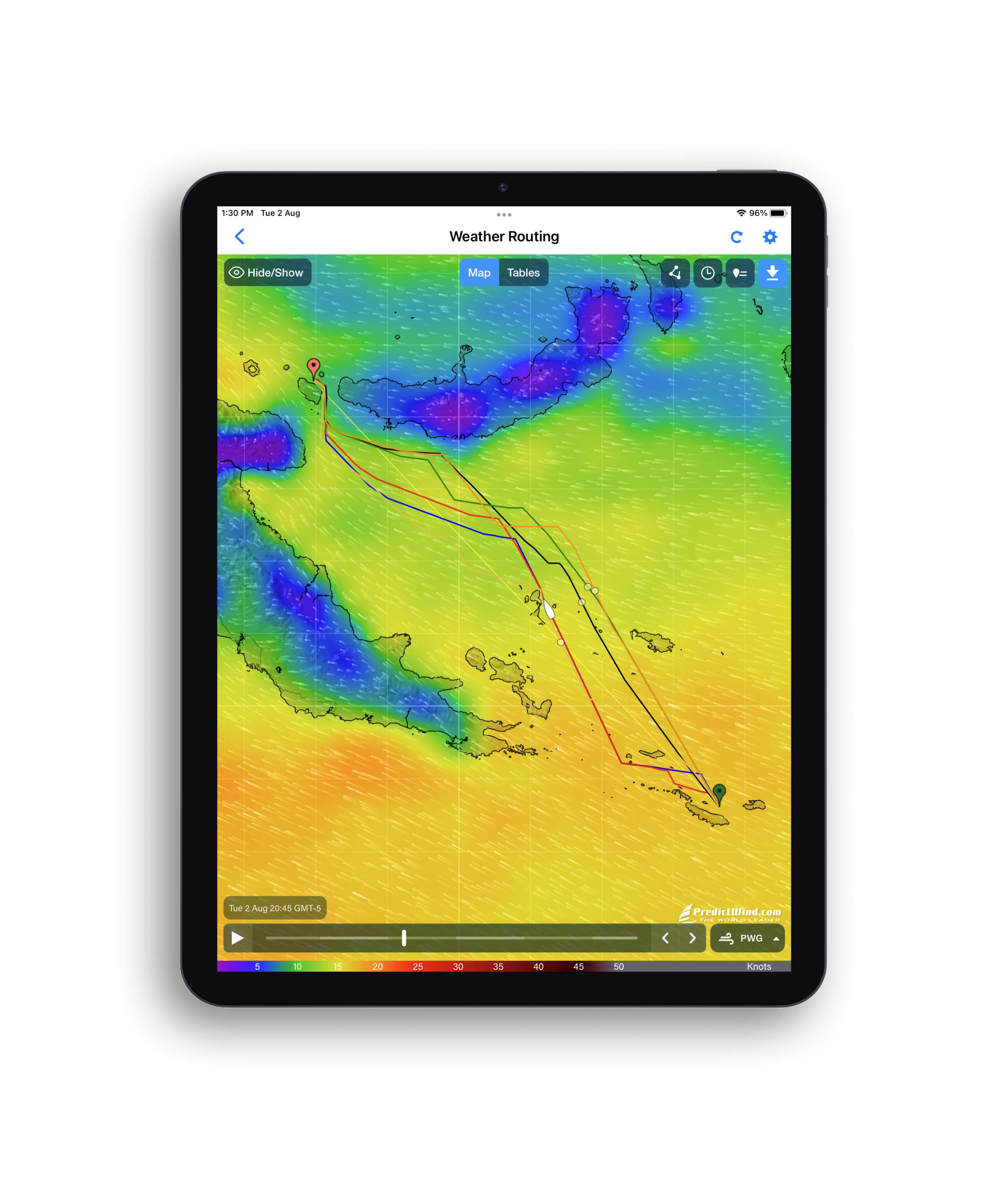
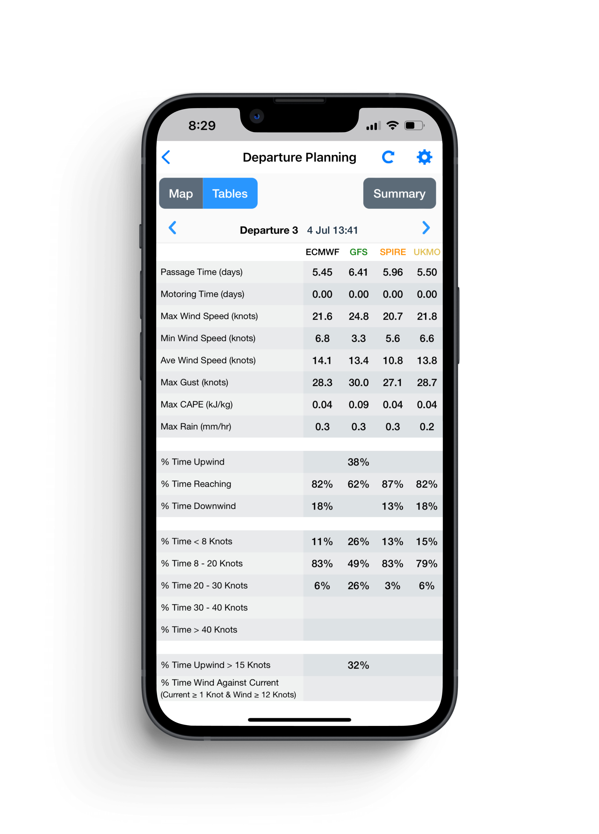
Bilger gave an example of how he used PredictWind in a recent trip from Auckland to Fiji, along with one of PredictWind’s skippers. “Using our tool is just like Google Maps,” he said. “You put in your start, your destination, you put in the performance curve of the boat so it knows what it's going to do in different conditions. Then, boom, it gives the fastest route, and it gives you the weather along that route [based on] the six models, the wind, the wave conditions, the current. You also can do a departure plan, so it gives you the info for Day One, Day Two, Day Three, and so on.”
The platform even creates a hydrodynamic model based on your specific watercraft, showing how it will react in upcoming conditions. “So you put in it’s a monohull, this length, this beam, this displacement. And it actually has all the criteria to model that in any swell state. This shows what you’re going to experience [in that weather].” The system shows the degree of roll, vertical acceleration, slamming, and other factors, letting you know what to expect ahead of time.”
During their Fiji trip, PredictWind’s forecast showed a massive swell of nearly four meters coming in behind them. At first glance, Bilger and his team were apprehensive. But the model showed that although the swell was large, the effects (based on their craft) wouldn’t be bad. “Sure enough, we trusted the system and we were fine. We had these big swells but [they were spaced out] over quite a long period so we hardly noticed them.
"[Without PredictWind] I would’ve looked at those swells and thought, ‘Man… that’s product-breaking stuff.’ But nah, we’re really eating our own dog food here. We actually use [PredictWind] all the time like this, and it’s a game changer.”