
A veteran river runner turns 70, and heads off into the Peruvian wilderness to raft the Rio Marañón, the headwaters of the Amazon.
From The Outdoor Journal Issue 14.
Preparing to launch that first morning, an emerging dread crept up the back of my neck. Although I had run rivers for 42 years, including nine trips down the Colorado in the Grand Canyon, I had never faced a challenge like this one: a gradient nearly equal to the Middle Fork of the Salmon, four foot wave trains, big pour-overs, surging eddys, seemingly endless rock gardens. I was to carry the two large kitchen boxes. These held the four-burner camp stove, the cast iron Dutch oven, all the pots and pans, the dishes, the coffee press and spices. Throughout this adventure my greatest fear was putting the entire trip in jeopardy. One mistake navigating this critical equipment down 310 miles of hurtling, surging, relentless whitewater and all our cooking gear would be at the bottom of the river.
The voice in my head muttered, “You must be out of your mind. What do you think you’re doing?” But it was too late to turn back; I had come too far and everyone else had a craft to navigate.

Sometimes for veteran river runners, simply the general description of a free-flowing river in a far-off place is enough to capture and hold the imagination. The Rio Marañón was that place for me. Add world-class whitewater, the peril from future dam development to the entire river and to all the people who live along its banks, and the chance to add my voice to preservation: a mission was born.
I had first heard of the Rio Marañón through a message posted on a site devoted to the Colorado River through the Grand Canyon. It described the beauty and difficulty of running this river and the destruction that it faces from numerous proposed hydroelectric dam sites. The message mentioned Rocky Contos, outfitter and guide, who discovered the Marañón for himself in 2012. I contacted Rocky to learn more and began research about the river.
World-Class White Water
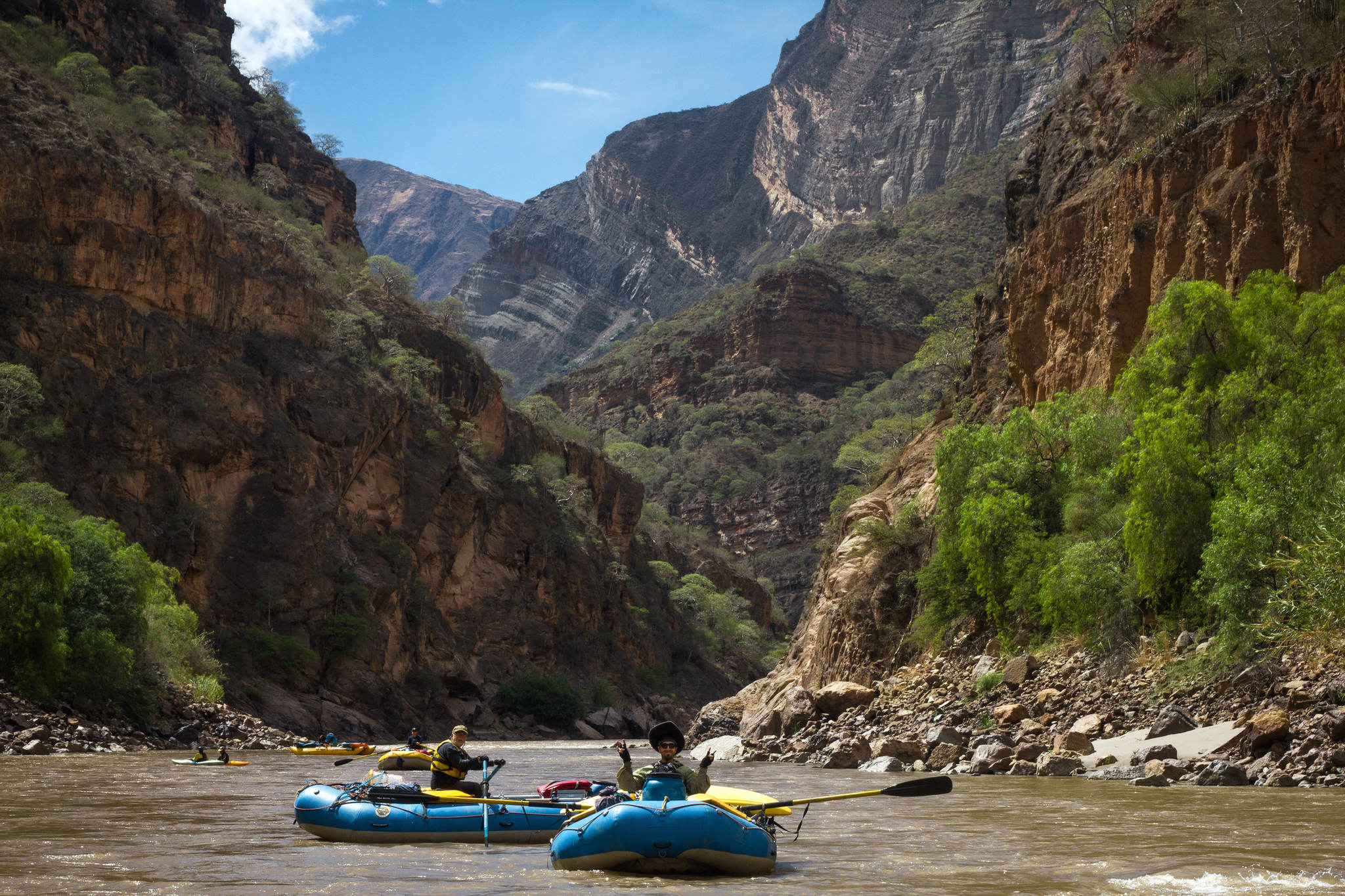
I learned that the Rio Marañón forms on the eastern side of the Peruvian Andes, rising from glacial runoff and snowmelt. It plunges north at a gradient averaging from 15 to 30 feet per mile, two to four times that of the Colorado. Hundreds of miles downstream the Marañón begins a broad turn toward Brazil where it enters the jungle, receives water from many other rivers, and is considered the mainstream headwaters of the Amazon. The Canyon of the Rio Marañón is among the deepest in the world. In many places the peaks overlooking the river are 10,000 feet above its level, twice as high as the South rim of the Colorado River in the Grand Canyon. In its upper stretches the Marañón Canyon is quite narrow with steep sides and limited beaches. Because the canyon receives only about 10 to 20 inches of rain per year, it is essentially a desert.
At Risk Ecosystem
Since the 1970s, foreign developers have studied dam feasibility all along the Marañón. In 2010, then-President Alan Garcia declared that energy-producing hydroelectric dam construction on the Marañón was in the “national interest”. As many as 20 dams have been proposed and many are under active study and consideration. These projects called Chadin II, Veracruz, and Manseriche would be at least 600 feet tall and would flood areas behind them for 45 to 125 miles. Any one of them would inundate and permanently destroy the ecosystem of the river upstream, submerge the villagers who live along and depend on the free-flowing river, and change forever the way of life along its banks.
Our Group to the Put-In
While shorter trips are more popular due to time constraints for participants, our plan was to run all 310 miles through the entire section of the Marañón known as the “Grand Canyon of the Amazon”. Our rendezvous hub was the city of Huaraz, situated at about 10,000 feet elevation on the west side of the Peruvian Andes.
Our launch group was an eclectic mix of ages and origins. We ranged from 23 to 70 years old and came from Italy, Uruguay, Chile, Peru, United States and Denmark. The six rafts were outfitted like any longer, commercial raft expedition. Although we had local guides with us, we were fortunate that Rocky Contos led the expedition, his ninth time down this section of the river.

Rocky is 44, tall, angular, and quite fit with a wry demeanor. He began kayaking in 1991 but also learned to raft in the mid-1990s to introduce more people to the wonders of river travel. He is a class V kayaker with many first descents in the United States, Mexico, Central America, Peru, Bolivia and Southeast Asia. He first ran the entire Marañón from its headwaters to Iquitos in 2012, having discovered it from a scan of rivers around the world. He led his first three large group Sierra Rios expeditions in 2013-14.
In just three and a half years Rocky has developed a first-class outfitting operation in a remote, rugged environment on an extremely challenging river. His guides and clients come from all over the world to experience this intense white-water challenge. He wants to demonstrate to the Peruvian government that eco-tourism is a viable economic development alternative to dam construction.
Time is Running Out for the River
As I learned from Rocky, and other sources, some of the dam projects have documented momentum and approvals for construction. Like the Bio-Bio in Chile, there may be only so much time remaining before dams are constructed and this river is lost forever. And, as I turned 70 in July, 2016, I engaged in some back-and-forth debate about whether I was up for the challenge, but I always knew how the argument would end: I had to go.
We enjoyed magnificent views of deep blue lakes and towering snowcapped mountains as our bus passed over the Andes at 14,500 feet. Proceeding down the Rio Puchka drainage, we came to the ruins left by the Chavi’n people. The Chavi’n preceded the Inca by at least 1000 years and occupied this area between 1400 and 400 BC. The mostly excavated Temple has a precise east-west orientation and fine stone construction.
After a seven-hour serpentine ride, we arrived at the put-in at an elevation of 7000 feet. Our trip came at the end of a dry season that followed one of the driest El Nino years on record. So, we were not surprised that the river was running at about 2000 CF (cubic feet per second), the lowest Rocky had ever seen. Though the river had smaller holes, additional exposed rocks made for more technical maneuvering.
Like typical raft supported trips in the USA, all rafts carried group equipment. I rowed a 16-foot self-bailer with 9 foot oars. Cargo included the two kitchen boxes, some food and camp needs, a personal duffle and water. Other boats had additional food supplies including two coffin-sized ice coolers on the cataraft.
The Challenge Ahead
From the put-in at about 7000 feet we rowed over the next 12 days to our re-supply point of Chagual, at about 3300 feet. The canyon walls are very steep, constrict the river, and create many difficult rapids, with countless class II and IIIs, roughly a dozen IVs and two Vs.
These high velocity rapids featured 4 foot high wave trains, big pour-overs, churning eddys and endless boulder gardens. I became more closely acquainted with some hazards than I would have preferred. On our second day we rowed through Yesojirca Narrows, where the river is constricted to nearly raft-width.
Sometimes, even when the water seemed somewhat flat, it would surge along a rock wall and suddenly a huge eddy would appear behind a nearly covered boulder that was enough to spin a raft completely around. Other times we chose to “read and run” rapids where the distance or terrain made it infeasible to scout. We would generally follow one of the guides through the major rapids and hope we could make the same moves.

One of the class V rapids in this section is known as Wasson’s Landslide. It was first mentioned by John Wasson, a member of a 1977 trip that described the obstacle in some detail. Rocky took charge of rowing each of the rafts through the upper part of Wasson’s but turned the oars back over to us for the last stretch.
Big Surprise On the Final Stretch
The major impediment in this last run of the rapid is an 8 foot drop into a great surging boil. Unfortunately, I missed a couple of strokes and the current pulled me toward the hole. I knew that going in sideways would be a complete disaster. Given my angle, the best option was rowing backward as hard as I could. I shot over the top and the boat landed upright in the surge. Within a nano-second, I was launched out of the boat and into the water as though I was teed up on the golf course. At first, I was pulled down and back into the churning water, but eventually my lifejacket brought me up for a welcome breath of air and I got to shore. The boat stayed upright and we lost no gear. However, my dignity was in serious disarray.
The steep canyon walls here seem ideal for dam construction. Three dams in this section alone are under active study: Yaku at mile 58, Cajas at mile 87 and San Miguel at mile 124. Each would rise hundreds of feet above the river and completely submerge the area upstream for a distance of at least 30 miles. These three dams would create stair step reservoirs, with no semblance of a river between.
As we worked our way downstream I visualized the impact on this beautiful canyon if it were submerged under hundreds of feet of water. Though the area seemed empty, it was not. Many side streams (quebradas) and smaller rivers joined the Marañón. At nearly every convergence with the river a small oasis of green signaled where a farmer had diverted the quebrada to create a planting area (chacra) for growing coca, bananas, mangoes, papaya’s, oranges and peppers. These chacras exist because the river and its side streams have formed a riparian bank with a flourishing ecosystem.
Several days into the trip, we camped just upstream of Sanachgan rapid and a well-established chacra. As we prepared to leave, a young couple came with their infant daughter and dog to see us off. If the Yaku dam is constructed, their farm and way of life will be destroyed.

Vulnerable Flora and Fauna
"Even the traces of ancient peoples who eons past lived along this river would be forever lost."The Marañón is home to a unique variety of plants and animals that could not survive the dams. Countless centuries of erosion from the steep canyon walls have formed river banks that flourish with trees, shrubs and wildlife. This is where the people live and their sustainable agriculture has developed over many generations. Submerge the canyon under hundreds of feet of water, and the fertile riverbank is gone forever.
Along this upper canyon and inner gorge, there are currently no roads from the put-in until the site of the proposed Yaku dam. Nevertheless, many people live along or near the river within this 58-mile distance. They rely on trails beside the river and those that lead up and over the mountains to sell their products and to obtain the materials they require, yet cannot produce.
From the beginning of our journey, we were serenaded during the day by cicadas. These large, fat bodied, leaf-eating insects, related to crickets and grasshoppers, live in the trees along the river. Fish, lizards, birds and other animals depend on the cicadas for their survival.
We were entertained often by a chattering chorus of loros, small green parrots that flock in the riverside trees. We also saw white and blue herons and Andean terns migrating from the Pacific to the Atlantic. Various waterfowl were present such as the torrent ducks that like to swim down rapids. Other smaller birds in the trees were frequently heard but seldom seen. These birds would be displaced by the dams, especially those dependent on small fish and insects in the flowing river.
Along the river bank ceiba, acacia, jacaranda, willow and reeds compete for growing room. If a dam raises the water level several hundred feet, these trees would drown. Only the ubiquitous cacti that resemble the saguaro in Arizona would remain.
The Marañón is full of fish. The upper sections of the river flow with cool water suitable for Andean trout. Further downstream, the sediment load of the river is home to several unique fishes such as catfish and carachama (a prehistoric-looking creature). Dams settle silt and release unnaturally clear, cold water, which would doom most of the native species.
Even the traces of ancient peoples who eons past lived along this river would be forever lost. Important cultural sites exist in many locations, including granaries like those seen on the Colorado at Nankoweop and tombs that still host bones. Built into the mountainsides near the river, these remaining structures and artifacts would be permanently submerged. These sites should be protected, not destroyed.
Chagual to Puerto Malleta
In Chagual we re-supplied food and ice. The river changed character dramatically from the constricted Inner Gorge into a much wider riverbed, sometimes with braided channels. The gradient moderated but was still almost twice that of the Colorado. Though still challenging, the rapids were mostly class IIIs. The few class IVs often had easier lines through them. Some of the longer, calmer sections of class II water gave us the chance to enjoy more of the magnificent scenery with clear views up to the rims on both sides. Four mega-dams are planned for this section of the Marañón: Rio Grande I and II, Chadin II and Veracruz. If all are constructed, the entire 188 miles of this river section would become one reservoir after another, just like the upper Grand Canyon area.
Tupén Grande
"The only lightbulb in the community is powered by some solar cells."While the river, rapids and Canyon side hikes were quite enjoyable, the most profound impacts for me were the villages, especially Tupén Grande. When we arrived on day 21 of our trip (mile 255), where “welcome” was spelled out with rocks, in English, a reception party met us. We immediately knew we had come to a friendly place. It was here that I came to understand most directly how a downstream dam called Chadin II would wipe out generations of a self-sustaining self-governing community that would have nowhere to go. We met Cesar Chavez, who is head of the Ronda, or town militia. He has been a leader and spokesperson for opposition to the Chadin II dam project, at mile 266, that would flood and destroy the village, and displace the hundreds of people who live in and around the area. As they did with Rocky, development operatives have attempted to intimidate Cesar to silence his opposition leadership.
Their village is accessible only via the river or by a 6 to 8 hour hike to the rim. There are no roads, no cars and almost no lights. The only lightbulb in the community is powered by some solar cells. The school, the village bodega filled with coca, communal buildings, homes and other structures are somewhat randomly located where someone decided to build. There is an extensive, communal irrigation system that supplies many produce gardens. The community focuses on the children who are outside often. Games are emphasized: volleyball for the girls and soccer for the boys.
I brought a donation bag with 50 items to share, mostly children’s clothes, and some shirts I no longer needed. Mardi Maack, another member of the group, brought four bags, that included clothing, shoes, eyeglasses and medical supplies. At the access point of Balsas we also met one of the villagers and brought him along with three 100 foot spools of 2-inch irrigation pipe for the village.
Among those who came to investigate the gifts was a little fellow named Antonio. He and his mother were among the first to arrive. My bag included a camouflage print shirt that was just his size. With his mother’s encouragement, he put it on and left to chase some of the other boys.
To show their appreciation for the supplies and donations we brought, eight of the village children performed some dances for us and the rest of the community. There was a large turnout and everyone enjoyed the show.
Like us, the people of Tupén Grande are in opposition to the Chadin II dam project that would flood their village. In speaking with the villagers and just being there, the resistance to the dam is palpable. Protests against the construction are everywhere. Online articles and videos of the opposition abound. This is a community working to preserve its way of life against the threat of an ill-conceived dam.
Though we enjoyed Tupén Grande immensely, we still had more than 50 miles to complete our journey. We made our last camp on a large island in the middle of the river about three quarters of a mile from the take-out point at Puerto Malleta. The next and final morning, I was the last to leave and eased my way into the converging channels into the main river. I looked back at our last camp and again rejoiced that I had come this far, seen so much and learned more than I could have imagined.
Social Impacts
The social impacts of these mega-dams would be enormous, provoking major disruptions in flooding cycles, fish migrations and sediment deposits throughout the Amazon basin with potentially disastrous, ecological consequences. The thousands living along the Marañón would be up-rooted to some unknown, undesirable location and the flora and fauna lost forever.
Any government is vulnerable to the boatloads of cash available to giant contractors and developers for whom bribery and payoffs are simply another cost of acquiring massive contracts. Peru is no exception. Three of the dams proposed for the Marañón are projects of Odebrecht, an international, Brazilian mega-development construction company. In December, 2016, Odebrecht agreed to pay a fine exceeding $2 billion for its corruption payments to governments throughout Central and South America, including $28 million to Peru. Its president was sentenced in the same week to 19 years in prison for his role in the scandal.
To the outside world, it is generally unknown whether any of the bribery payments paid in Peru were associated with dam projects. Unless uncovered by investigation, these payoffs will be known only to the government officials who received them and the developer minions who paid them. Nevertheless, the entire scandal highlights the enormous difficulty faced by the ordinary Peruvians living along and dependent upon the river as they battle the other devastating costs to the ecosystem and their way of life.
The argument for these dams is strong: the river is a Peruvian resource. The people of Peru, through its government, should determine how this resource shall benefit the whole country. The river represents much potential energy production that can either be sold to other countries or used internally for the betterment of the Peruvian people.
But there is another argument which is more holistic and existential. The people of Peru can save this jewel, leave the lives of thousands of people intact, preserve an eco-system that is a vital part of the Amazon drainage, and promote ecotourism, multicultural experiences and exchanges. The tourist monies spent along the river go directly to those who live there.
Building these dams would be a tremendous undertaking, with exponential costs. Some of the sites are located in very remote areas without roads, bridges or other infrastructure required to create a multibillion dollar, 500 to 600 foot tall dam. In addition, a massive high-voltage transmission grid would have to be constructed over some of the most rugged mountains in the world. This cannot be a wise use of resources.
Further media exposure of the true cost of these projects, including all the corruption involved, offers hope that political action can achieve results. Additional dams on the Colorado River in the Grand Canyon were prevented only by international publicity and public outcry that resulted in political compromise in Congress.
Call to Action
We need to take more action. For those who wish to add their voices to the call to save the Marañón, Sierra Rios offers several avenues. Following more than 1000 others, support can be added to the petition to the Peruvian government, opposing dam construction: Click Here to Sign the Petition.
Donations can be made to enhance efforts to support and encourage the people living along the Marañón. Finally, trips are available for novices and river veterans alike who are adventurous enough to experience this incredible river for themselves.
Although the Marañón and its Canyon on the east side of the Andes may seem a remote, harsh and arid place, it is teeming with life and nature in balance. The Peruvian people are best served by an untouched Marañón.
I certainly feel blessed to have run and experienced this mighty river and to have met some of the people who live along its banks. Its volume is modest but its course is true. Compelling, inscrutable, restless and indifferent, so far, this free-flowing river rolls on.
Feature Image © Alexander Weinert
If you are looking to embark on your own rafting adventure, check out our approved operators on The Outdoor Voyage.


